Terrestrial 3D Laser Scanning

AUAV is a pioneering force in the domain of advanced UAV operations. We are known for our flawless inspections and data collection capabilities, all powered by the latest UAV technology. Our expertise, however, extends beyond just aerial solutions.

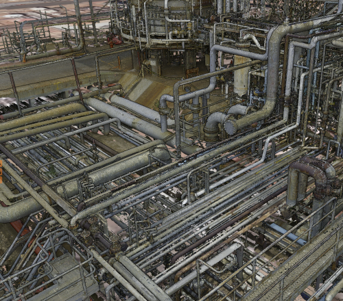
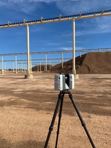
We utilize advanced data capture techniques that allow us to strategically collect data on internal structures. This is achieved using terrestrial laser scanners, which enable us to construct detailed models of enclosed structures. These models provide a comprehensive view of the interior structures, offering valuable insights that can guide decision-making processes.

Our unique data capture processes set us apart from other UAV companies. They are just one of many examples of how we leverage technology to provide superior services. But our innovation doesn’t stop there.
With our proprietary software Insite™, we take the analysis of inspection data to a whole new level. This software allows for post-capture modifications and annotations, providing a dynamic tool for data analysis. This means our clients can interact with the data, adjusting and documenting annotations that can help them better prepare for future maintenance and operations.

In essence, AUAV is more than just a drone company. We are a technology company that uses drones and other advanced technologies to provide high-quality, data driven solutions. Our commitment to innovation and excellence is what makes us an industry leader in our field of expertise.

For more information on Terrestrial Laser Scanning, contact us.

Benefit From Experienced Terrestrial Laser Scanning

Terrestrial laser scanning.
Typical applications include:
  • Rail infrastructure.
  • Interior visualisations.
  • As built plans of plant.
  • High accuracy measurements.

Frequently Asked Questions

Terrestrial laser scanning is ideal when detailed measurements of building interiors, industrial facilities, or enclosed structures are required. Since the scanner operates from ground level, it captures highly accurate spatial data in areas where aerial surveys may have limited visibility or access.

3D laser scanning services are commonly used for industrial plants, rail infrastructure, commercial buildings, manufacturing facilities, and construction projects. They support as-built documentation, renovation planning, engineering design, and long-term asset management.

Every project begins with a review of the site and the required deliverables. Our team captures millions of measurements from multiple scan locations before processing the data into accurate digital models, drawings, or a point cloud survey, depending on your project requirements.

Yes. Industrial laser scanning can be carried out in many operational environments with careful planning. The approach is designed to collect accurate spatial data while working within site access, safety requirements, and operational constraints.

Deliverables vary depending on your project objectives and may include registered point clouds, 3D models, CAD drawings, floor plans, and other digital outputs. As an experienced laser scanning survey company, we provide data in formats that support engineering, maintenance, and asset management workflows.

The most suitable survey method depends on your asset, site conditions, required accuracy, and final deliverables. Our team will assess your project requirements and recommend the best approach, including facility 3D scan survey solutions and FARO laser scanning services where appropriate.

Get in touch with us today